Authored by Ryan Unks
Rangeland ecosystems in semi-arid, arid and montane climates tend to be highly biodiverse while also supporting pastoralism and agro-pastoralism. These ecosystems are increasingly targeted for sustainability interventions such as carbon sequestration, afforestation, restoration, and wildlife conservation.
In recent decades, development of geospatial data sets have enabled new global ways of viewing and analyzing relationships between livestock, land, and wildlife. In a paper published last month, I showed how these geospatial data represent mobile extensive pastoralist production systems and their relationships with rangeland ecosystems in limited and misleading ways. I focused on examples of remotely-sensed land cover and vegetation productivity data, spatially explicit global livestock data, and the types of analysis they are commonly used for. These data and analyses provide a false sense of producing reliable new knowledge at scale because they overlook or distort ecological heterogeneity and variability and much about pastoralism as an important livelihood and way of life. This can create a deceptive sense of certainty and generalizability about conservation challenges and solutions in pastoralist rangelands.
Rangeland ecosystems tend to be heterogeneous at fine spatial scales, contain interspersed woody and herbaceous vegetation patches, and their dynamics are driven by variable climates. Characterizing and tracking their dynamics using archival moderate-resolution and low-resolution remotely sensed imagery is difficult. This leads to poor understanding of how they change over time, and often, misattribution of land cover change or declines in productivity to local pastoralist management systems. Remote-sensing can also overlook how ecosystems are enhanced by pastoralism (e.g. grazing and practices of management and care can create landscape heterogeneity, enhance biodiversity, and stimulate ecosystem processes).
Another commonly used type of data, global livestock layers, estimate spatially-explicit livestock densities using government census data that are then downscaled using various methodologies. While the creators of these data are transparent about inherent inaccuracies and uncertainties, this is often not acknowledged by data users. Further, these data are spatio-temporally static and do not account for well-known dynamics of livestock populations or herders’ mobility practices that require flexible, often informal access to land, which are usually not documented in ways that are easily incorporated into maps. Overlooking all of these limitations can lead to assumptions that livestock have universal impacts like emissions or land degradation. This can also devalue pastoral economies, lacking recognition of pastoralism as a productive, reliable, widespread livelihood, and neglecting the social, political, and economic factors that enable mobility and livestock management in response to ecological variability.
When multiple types of data, from remote sensing and globalized livestock data, are combined in analysis, the limitations and uncertainties of the underlying data are compounded. These combinations can further oversimplify relationships between wildlife and people and amplify dominant narratives and normative views that pastoralist livestock and wildlife always compete or otherwise negatively interact. For example, livestock data used in anthropogenic pressure indices can overlook synergies with biodiversity; when wildlife occur on pastoralist land, they are viewed as threatened, rather than benefitting from pastoralists’ land management.
The deceptive sense of generalizability and certainty these analyses lend creates a high potential for misrecognition of pastoralists’ ways of relating to land, for crisis narratives to justify superceding pastoralists’ own ways of managing and accessing land, and to in turn create distributive injustices due to changes in land use but also the benefits derived from conservation interventions. Additionally, epistemic injustice cuts through all of these due to a lack of concepts that can adequately bridge conservation science and geospatial analsysis with pastoralists’ own knowledge as well as social science studies of pastoralism. For example, epistemic biases can undermine recognition of pastoral land use, livelihoods, ecological relations, ways of knowing, and ways of relating to each other.
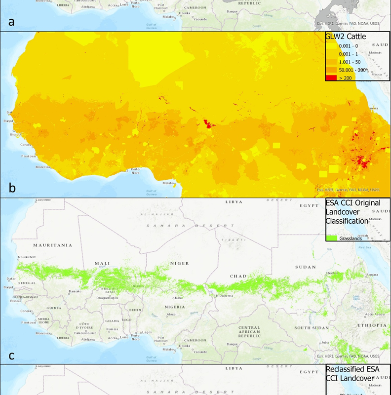
One prominent example by Strassburg et al. used global analysis to distinguish between ‘natural’ and ‘cultivated’ grasslands to prioritize restoration locations. Following their procedure (see figure below), if an ESA landcover data pixel is classified as grasslands, the pixel falls within an ecoregion classified as non-grasslands, and one or more head of cattle, according to global livestock data, is present per square kilometre, the pixel is re-classified as non-natural ‘cultivated grassland’. If the cattle are below this value it is classified as a natural grassland. However, quick comparison to high-resolution imagery shows it is extremely unlikely that this vast stretch of land in the Sahel shown in the map below, which replicates their methodology, is planted grassland.
This example crystalizes many problems with global data. Given the difficulties of distinguishing between grassland and open canopies in these dynamic environments, as well as characterizing land use, the potential for inaccuracies in much wider examples is considerable. However, this example also underlines deeper conceptual problems with global geospatial data and analyses of rangelands. Arid areas of the Sahel were ultimately prioritized in Strassburg et al.’s models because of the presence of the disturbed vegetation condition they claimed to be able to predict, but also due to the relatively low cost of restoration interventions they assumed. This assumption of low cost was only possible because the economic value of pastoralism was made largely invisible and its economic returns were underestimated. This underestimation also repeats a general pattern, in which pastoral livestock keeping is often assumed to be ecologically harmful, that dates from colonial misunderstandings of pastoral practices. Geospatial data analysis risks reinforcing narratives of the powerful, presenting pastoralist lands as inefficiently used places where sustainability interventions should be prioritized.
Ultimately, geospatial analyses can render invisible many potential synergies among wildlife biodiversity, ecosystem functions, and pastoralism, an important livelihood that supports millions. They cannot generalize the context-dependent socio-ecological processes characteristic of pastoralist rangelands at large extents. As a result, geospatial analyses can create a deceptive sense of certainty that risks providing misleading evidence in support of inappropriate interventions that have strong potential to perpetuate injustices. A humble approach to geospatial analysis that acknowledges uncertainty and reflexively should consider three dimensions of geospatial analyses of rangelands: 1) the technical ability of geospatial data to account for ecological and social variability; 2) the compound uncertainties that arise when multiple data layers are used to produce knowledge about socio-ecological interactions; and 3) how uncertainties become masked by epistemic biases, creating a deceptive sense of certainty and generalizability.